By Joseph M. Lee III | Photos provided by Augusta Museum of History
When Congress approved President Woodrow Wilson’s declaration of war on April 6, 1917, the U.S. Army numbered only 200,000 men. Roughly two-thirds of that total were regular army and the rest were National Guardsmen who had been called to federal service for duty on the Mexican border.
The next month, the War Department authorized the building of cantonments to carry forward a training program for 4,800,000 members of the armed forces who would eventually participate in World War I. Construction progressed rapidly on 32 camps and cantonments to accommodate the National Guard and Army divisions authorized by the War Department.
There was stiff competition among cities throughout the country to obtain one of the cantonments and Augusta was no exception. In May 1917, city officials and the Board of Commerce formed a committee to work on details to launch a bid for a camp.
Nesbit Wingfield, commissioner of public works and the city engineer, prepared a report for a camp on lands lying west of Lake Aumond and extending to the Columbia County line. Augusta was selected as a camp location, but within days the Secretary of War issued new orders for camp locations, requiring the city to start the process all over again.
At this point, go-getter Wingfield traveled to Charleston, S.C., to the Southeastern Department of the Army to convince officials that a new location nearer the city could accommodate a large tent city for a National Guard camp of the type the Army needed. He spent the day working on a proposed layout with Lt. Col. Ladue, chief engineer of the Southeastern Department. Ladue approved and Augusta was again recommended as a camp location.
On July 6, 1917, Wingfield was notified that the selection had been approved and he was requested to act as the government engineer in laying out the camp.
It was named Camp Hancock in honor of Maj. Gen. Winfield Scott Hancock, a U.S. Army veteran of the Mexican-American and Civil wars. The War Department selected the camp for the National Guard’s 28th Division, formerly the National Guard of Pennsylvania called the Keystone Division.
Construction Quartermaster Major G.B. Stricker arrived in Augusta on July 18, 1917 and met with Wingfield who had been designated the supervising engineer. Clearing of the site began the next day. T.O. Brown & Son was authorized to contract for 4,363,192 board feet of lumber and W.S. Brant, superintendent of the Georgia Railroad, coordinated the building of 4.32 miles of tracks into the camp.
Wingfield took only a week to lay out the camp and Major Stricker filed a completion report in December 1917: “The Camp Site is high and well drained and Division Headquarters, the highest point on the Camp Site, is something over two hundred feet above the Railroad. The surface is sandy, underlaid by clay at depths varying from three to ten or more feet and practically the entire area built upon was covered with pines and black-jacks.”
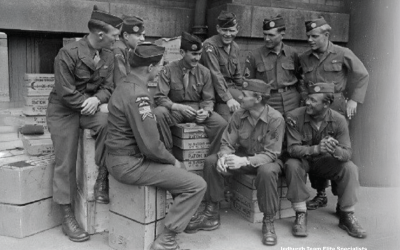
Units of the 28th Division began arriving before the initial building phase was completed. Motor Truck Company No. 21 with 20 men and 30 trucks arrived July 29, 1917. By Sept. 16, a total of 27,122 men had arrived along with 1,380 animals, 72 guns, 192 caissons, 7 reel carts and 57 trucks.
The troops had to help complete the work on the camp. Electrical work was running behind because of a shortage of skilled electricians. At one time, there were 100 civilians wiring buildings and 500 soldiers wiring tents. When all civilians were moved to wire the Base Hospital they left sample wired buildings or each type under construction so that soldiers could complete the wiring jobs.
The camp eventually evolved into a division-sized tent city supplemented by 1,319 temporary buildings consisting of mess halls, showers, latrines, stables, garages, store houses, infirmaries, administration buildings, barracks for various uses and miscellaneous structures.
The camp site proper measured 1,777 acres and the entire tract 13,811 acres. Wrightsboro Road and Wheless Road (now Highland Avenue) ran through the camp. Nine miles of clay and sand roads were built in and around the camp and base hospital. Sewer lines were not installed initially, but were added later in the latrine areas and at the base hospital.
In its final configuration, the camp could accommodate 45,099 troops. Highest number of troops in camp in any one month was 35,148 in October 1918. Lowest number was 11,824 in May 1918 when the 28th Division went overseas.
In addition to the divisional training site and hospital, a machine gun training center, an ordnance supply school and an officer’s training school were established. The camp also was home to units of the Air Service, Coast Artillery, Cavalry, Engineers, Medical Department, Motor Transport Corps, Ordnance and Quartermaster Corps.
The camp was designated as a demobilization center after the war. It was ordered salvaged on Jan. 2, 1919 and was abandoned March 27 and turned over to a caretaker detachment.
To the casual observer, nothing remains of Camp Hancock. Years of urbanization has seemingly obliterated all remnants of this once burgeoning camp of more than 30,000 inhabitants. Previous media accounts of the camp’s location have generally placed it on The Hill on the west side of Augusta. To put the exact location in perspective, let’s take a walking tour through today’s neighborhoods and describe locations of various elements of the camp proper. Who knows? We might even find remnants of the camp here and there.
We will start at Daniel Field. In 1917, the area was cleared of all trees and brush and used as a parade ground. Large formations of troops practiced their maneuvers on the field which was very warm and dusty in the spring. As a child, my mother Mary M. Fletcher visited a friend on Ohio Avenue. They made a pail of lemonade and lugged it onto the field where some lucky soldiers quenched their thirsts.
Wheless Road did not jog eastward as it does today near the Daniel Field hangars, but continued straight north to intersect with Wrightsboro Road just across from where Iris Drive intersects. There was a YMCA building in the southwest corner of Wheless and Wrightsboro about where the Pizza Hut is located today.
The westernmost reservoir of the City Waterworks was dug out, but not filled with water. The site was used for physical training and bayonet training by the 28th Division. Messages on postcards sent home to families and friends showed the soldiers did not like to train there because there was no breeze in the hole and it was always hot and humid. Many Augustans lined the reservoir banks to watch the training sessions. The extreme western end of the reservoir embankment was a favorite spot for photographers to set up their cameras for panoramic views of the 56th Infantry Brigade mess shacks and tents.
Coming down that embankment, you now come to Buena Vista Road. It is on the site of Reservoir Road in the camp which intersected Wrightsboro Road just about where Pine Needle Road intersects Wrightsboro Road today. It was the eastern end of the camp on the north side of Wrightsboro. Main thoroughfare through the camp on the north side was named Pennsylvania Avenue. It started at Reservoir Road (Buena Vista Road) and ran west parallel to Wrightsboro approximately to where Pine Needle Road is today. It was 8,500 feet long and ended near Myrtle Court.
 Mess shacks lined the north side of the avenue. They were used by soldiers living in the tent city located between Pine Needle Road and Lake Forest Drive. Park Avenue runs through the middle of the tent city. The latrine line was located approximately where today’s homes are located on the south side of Lake Forest Drive. The area south of Pine Needle Road where Cardinal Drive is located was cleared and used as a drill ground. This section of the camp was occupied by troops of the 56th Infantry Brigade.
The next section was just west of today’s Comfort Road. It was the location of Headquarters Troop, 103rd Headquarters Train and 103rd Field Signal Battalion. They occupied the site north of Pennsylvania Avenue where the old Oliver General Hospital was located. Directly south below Pennsylvania Avenue were 28th Division Headquarters and Military Police Headquarters. These were located approximately where the new golf course clubhouse is located today. A camp road from division headquarters to Wrightsboro Road ran just west of and parallel to Magnolia Drive.
Farther to the west the Augusta Municipal Golf Club’s course, known today as “The Patch,” covers a large portion of the camp. There is a short section of Pennsylvania Avenue on the course used as an access road by golf club personnel. Footings for mess shacks on the north side of the access road have been uncovered by the author in the past.
The first area west of Brigade Headquarters was the site of the Field Artillery Service Training Camp. The old Oliver General gymnasium was in that area fronting on old Pennsylvania Avenue. Going farther west, we have the site of the 55th Infantry Brigade. Golf links cover most of this site. The Augusta University gymnasium was built atop the 110th Infantry camp. The western end of the 55th Brigade camp is covered by the old Myrtle Court Apartments.
The Camp End Road at the western edge of the 55th Infantry Brigade site ran south from Pennsylvania Avenue across Wrightsboro Road about where the entrance to Governor’s Place Apartments (now called The Onyx) is today. About 100 yards south of Wrightsboro Road, it turned east and ran parallel to Wrightsboro to a point just beyond where Damascus Road is today. The Old Government Road running east from Damascus is a portion of the old camp road. That old camp road running through the camp on the south side of Wrightsboro Road was renamed Stewart Avenue. The southern portion of the camp was the site going from west to east of the Ordnance Training Camp, the Signal Corps Camp for Motor Mechanics and the 103rd Regimental Engineers and their stables. The Georgian Place Apartments are on the Ordnance Training Camp site. The Golf Park Apartments (now called Falcon Crest) are on the site of the Signal Corps Camp and the old Damascus Road Apartments were on the 103rd Regimental Engineers site. Large depressions from the latrine line in the Signal Corps Camp can be seen in the woods.
The Old Government Road was called Cut Off Road in the camp. Walden Drive within the golf course was the eastern portion of Cut Off Road. It intersected Wheless Road at the current entrance to the golf course. The camp bakery was located in the north sector of the intersection.
The 103rd Sanitary Train and 103rd Supply Train camp site was parallel to Wheless Road on the west side running south from the current hangar sheds on Daniel Field to the camp bakery site at the golf course entrance. Runway 5 at Daniel Field and the golf links cover the entire site.
The 53rd Artillery Brigade covered the slopes south of the V.A. Hospital (formerly Lenwood) from Wheless Road east 3,300 feet. The main roadway through the camp was named Artillery Road or sometimes Tyler Road. It cut across present day Ohio Avenue, Pennsylvania Avenue and Maryland Avenue north of Park Way Drive. The site is now covered by houses on Shamrock Drive, Eastland Drive, Kelly Street, Clairmont Drive and Hillsinger Road of the Highland Park subdivision.
The Base Hospital was located south of Wrightsboro Road and cut across present day Whitney, Heath and Stovall streets, with the eastern most edge at Johns Road. Present day Minto Street, Forster Street and Devere Street are within the site as is Pendleton King Park.
The Officers Training School site was located on both sides of Church Road, now called Jackson Road just north of Wrightsboro Road. Roads were constructed and barracks built in the eastern section just before the camp closed. The cemetery across the street from Pierce Memorial United Methodist Church is on the site as is Alpine Drive Road.
The rifle range was located south of Milledgeville Road between Old McDuffie Road and New McDuffie Road. The area is split in half from north to south by the Bobby Jones Expressway. Some of the range butts can be found on the north side of Old McDuffie Road near the Lumpkin Road intersection. This site was abandoned at the time of the departure of the 28th Division.
Remnants of practice trenches are visible today at the end of present day Edison Drive off Barton Chapel Road.
The Auxiliary Remount Depot was located on present day Elbow Branch Road off Gordon Highway. The embankment for the railroad spur and a concrete structure can still be seen today.
The Artillery Range was on the site of present day Fort Gordon.
Appears in the October 2020 issue of Augusta Magazine.